Raw Deliverables
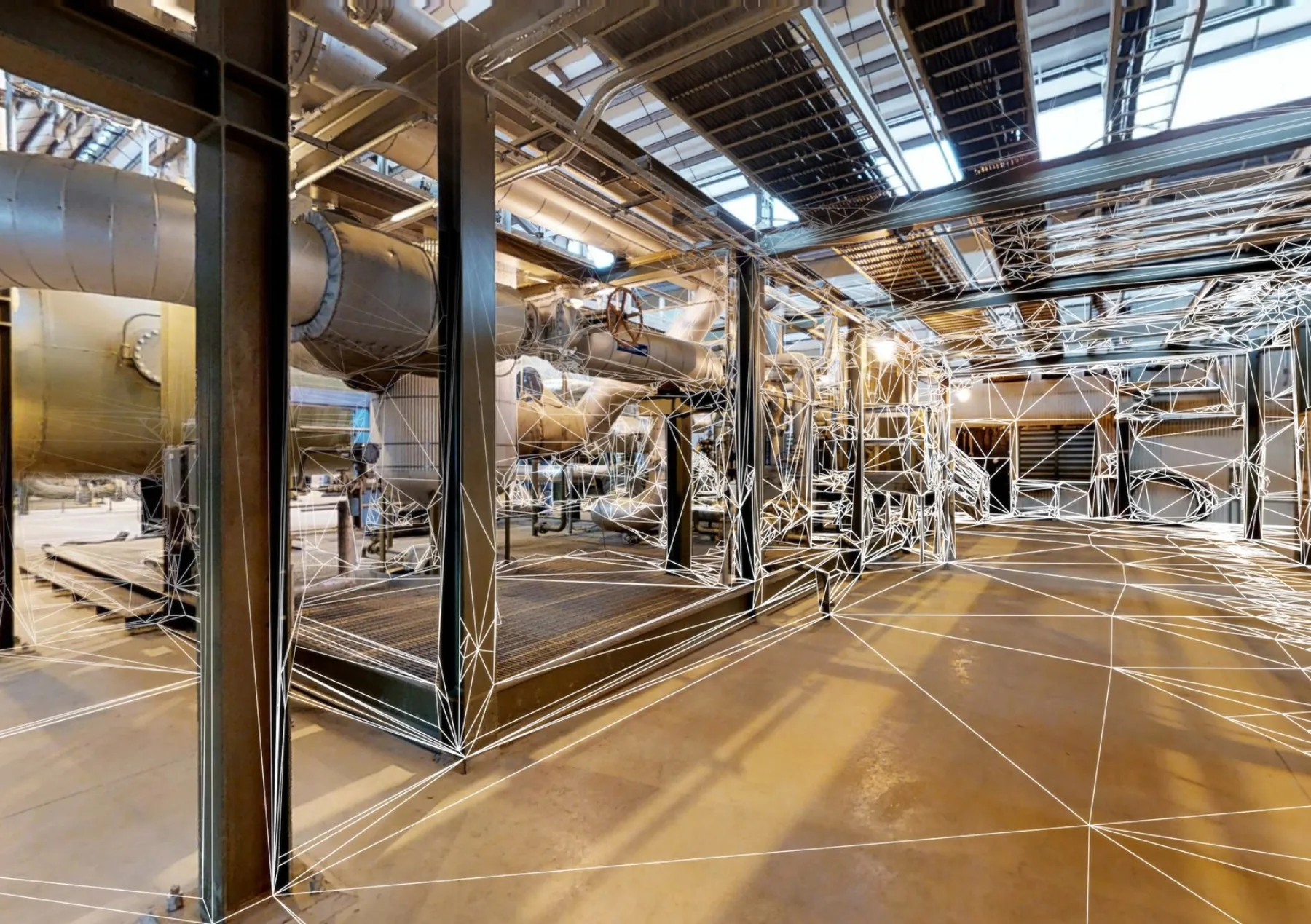
Point clouds, the source of truth.
Registered LiDAR point clouds delivered in the format your downstream tool wants. Civil engineers, surveyors, structural teams, BIM coordinators, and visualization shops all work directly off the cloud, no translation, no loss of fidelity.
What it is
Millions of points. One coordinated dataset.
A LiDAR scanner fires laser pulses across a 360° field of view, recording the distance to every surface it hits. A single scan position captures millions of measured points; a typical project takes dozens of positions across the site, then registers them all into a single coordinated point cloud.
The registered cloud is the source of truth. Floor plans, BIM models, surface meshes, volume calculations, every downstream deliverable on this page and the others under /services/lidar is derived from this dataset. Some clients want the deliverables. Some clients want the cloud itself and the deliverables come from their own pipeline.
We deliver both ways, and we deliver in the format you need.
Formats
Delivered in your pipeline's format.
-
.rcp / .rcs
Autodesk ReCap project + scan files. Native for AutoCAD, Civil 3D, and Revit. Default delivery format for AEC clients.
-
.e57
Open industry standard. Cross-vendor compatibility with Leica Cyclone, FARO SCENE, Trimble RealWorks, and most third-party tools.
-
.las / .laz
Survey and GIS workflow standard. Used by surveyors, civil engineers, and anyone working in ArcGIS, QGIS, or Global Mapper.
-
.pts / .ptx
Plain-text point exports for downstream custom processing or proprietary workflows.
-
.rcm / .obj / .fbx
Mesh exports when the project needs surface geometry instead of (or alongside) the cloud, render-ready or game-engine-ready.
-
Indexed web viewer
Browser-accessible navigable point cloud, drop a link in an email and anyone on the project team can walk through the scan without installing software.
Use Cases
Who actually uses raw point clouds.
-
Civil and survey engineering
Earthwork volume calculations, grading verification, drainage analysis, and as-built site documentation for civil projects. Delivered in the survey datum the project requires.
-
Structural analysis
Existing-condition documentation for retrofit, seismic upgrade, and re-occupancy projects. The point cloud is the dimensional reference structural engineers measure against.
-
Design coordination
Multi-discipline teams reference the same cloud from inside Revit, AutoCAD, Civil 3D, or NavisWorks. One source of truth, no version drift.
-
Forensic and dispute documentation
Time-stamped, registered point clouds capture conditions at a specific moment, useful for litigation, insurance claims, and construction-defect disputes.
-
Game, AR/VR, and visualization
Decimated and meshed exports for Unreal, Unity, and visualization pipelines where the cloud is the basis for a real-world digital environment.
-
Volumetric and stockpile measurement
Aggregate stockpiles, debris piles, fill and cut earthwork, measured to the centimeter from a single scan rather than estimated.

Specs
How the data comes off the scanner.
- Registered across all scan positions to a single coordinated dataset (typical registration error well under 1cm)
- Color-balanced if true-color points are needed for visualization, or intensity-only for analysis workflows
- Decimated to a target point density on request, full-resolution data sets can be 50–500GB; most design teams want a leaner working file
- Coordinate system aligned to project base point, survey control, or geo-referenced if GCPs were placed on site
- Cloud-hosted viewer link included for stakeholder access, no software install on the design team's side
Matterport Service Partner
MatterPak exports, straight from the cloud.
MatterPak is Matterport's bundled high-resolution asset export, point clouds, schematic floor plans, and OBJ meshes pulled directly from the Matterport Cloud. As a Service Partner, we package and deliver MatterPak alongside the point cloud exports above when a project benefits from both pipelines.
For teams already working inside the Matterport ecosystem, MatterPak is the fastest way to get scan-derived assets into a downstream tool. For teams working in survey or CAD-first pipelines, the .rcp / .e57 / .las exports remain the primary deliverable.
MatterPak product details and capabilities are documented in Matterport-published partner materials.
Often paired
Goes with the rest of the LiDAR stack.
Common questions
Point cloud delivery, answered.
-
What file size should we expect?
Depends on the scan scope and how much you decimate. A single residential property at full resolution is typically 5–15GB. A multi-floor commercial building runs 50–200GB. We almost always deliver both a full-resolution archival cloud and a decimated working cloud (usually 1–5GB) for day-to-day design work. -
Can the point cloud be tied to a survey control network?
Yes. If a licensed surveyor places ground control points before the scan, the point cloud registers to their control network and inherits the coordinate system. Without survey control, the cloud uses a local building datum, fine for as-built drawings and BIM, but not for civil or GIS workflows that need geo-referencing. -
How do you handle reflective surfaces, glass, and tight cavities?
Reflective and transparent surfaces are a known weakness of LiDAR, laser energy passes through or bounces unpredictably. We mark those areas during the scan and either field-verify with a tape measure or supplement with a different sensor (photogrammetry, total station) where the project needs it. -
Do you deliver in a specific software's native format?
Yes. Tell us your downstream tool and we'll deliver in whichever native format works best for your pipeline. Most AEC clients want .rcp for the Autodesk stack; most surveyors want .las; most game/visualization clients want .e57 or meshed exports. -
How long is the point cloud usable?
Indefinitely. The cloud is a static dataset, once it's archived, it can be referenced for years. We keep an archival copy on cold storage for active clients. For property owners who want to keep the cloud as a permanent record, we hand off the archival files at project close.
Get started
Need point cloud data? Send the scope.
A 10-minute call covers site size, downstream software, and whether you need geo-referencing or a local datum. Estimate back within 24 hours.